The Ministry of Environment has taken delivery of and launched the new forest monitoring system. But can it target the most common modus operandi – overloading –, distinguish relevant alerts from false ones, and help authorities prioritise inspections in high-risk areas based on objective and transparent criteria? WWF-Romania is inviting the authorities to a discussion where they can present the reports and identify the best solutions for making effective use of the new tools. How these tools are used will determine whether we can close the existing gaps in SUMAL and shift enforcement from detecting illegal activities to preventing them.
The Ministry of Environment, Waters and Forests has announced the completion of the integrated forest monitoring system, financed through Romania’s National Recovery and Resilience Plan (NRRP). The investment, worth more than RON 272 million, combines three technologies: satellite monitoring of forest vegetation, AI-powered video monitoring of timber transport, and airborne and terrestrial LiDAR scanning of forests.
This is an infrastructure that WWF has supported and called for over several years. As early as 2020, however, we warned that technology alone cannot solve the problem of illegal logging: the focus must be on prevention and on addressing the causes that make these illegal activities possible. And in 2023, when Romania had NRRP funding available, we called for these investments to be used to close the gaps in SUMAL and shift the control system from detecting illegal activities towards preventing them.
The infrastructure is now in place. The next step is to find out whether the functionalities these investments were intended to deliver are actually there and, above all, how they will be used. The effectiveness of the entire system will depend on how these tools are put into practice.
How Do We Identify Relevant Alerts and Use Enforcement Resources Efficiently?
The first component of the new system uses satellites to monitor approximately 70,000 km² of forest vegetation. Sentinel-2 images will be automatically compared, and the system will generate alerts when changes in vegetation are detected.
It sounds simple: trees disappear, an alert is generated. In reality, things are more complicated.
A change detected by satellite does not automatically mean illegal logging. It could be a wooded grassland, an authorised logging operation within the national forest fund, or an area affected by wind, snow or other natural factors. If the system does not use accurate, up-to-date reference data and does not filter these situations effectively enough, inspectors could end up investigating numerous irrelevant alerts and wasting resources allocated to enforcement.
The Ministry now states that satellite imagery will be correlated with information on authorised logging operations and areas affected by natural disasters. This is a necessary step, but particular attention needs to be paid to the working procedures: what GIS data on the National Forest Fund will be used as a reference? How and by whom will alerts be analysed, and how will field alerts be prioritised?
The purpose of the technology should be precisely to make more efficient use of limited enforcement resources and direct inspectors to where there is a genuine risk.
Can Artificial Intelligence “See” How Much Timber Is on a Truck and Then Issue an Alert if the Transport Declaration Has Been Falsified?
The second component of the investment could play a decisive role in tackling illegal timber transport.
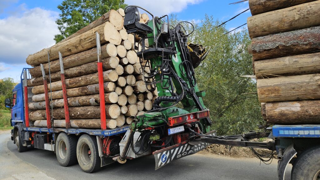
A total of 700 licence plate recognition cameras and 350 advanced-analysis cameras have been installed at 350 monitoring points. The images will be cross-checked against SUMAL data, and the system should identify undeclared transports, route deviations, multiple transports using the same transport document, and discrepancies between the transport itself and its accompanying documents.
But one of the most important discrepancies is the actual quantity of timber being transported compared with the quantity declared in the documents. This is precisely where what WWF has for years called the “digital fingerprint” of timber transport comes into play.
In 2024, when the Ministry of Environment commissioned the development of the system, WWF noted that the project aimed to create a system capable of automatically generating alerts and integrating data from available sources in real time. At the time, we considered that this investment could lay the foundations for an effective SUMAL 3.0 and close the gaps WWF had identified over the years.
Now we want to know whether this technological promise has become a reality.
Can the artificial intelligence algorithm developed through the project estimate the quantity of timber being transported and generate alerts when it significantly exceeds the volume stated in the transport document? Has the accuracy threshold set out in the terms of reference been achieved, including the identification of loads exceeding the declared volume by more than 20%?
This is not a theoretical question. WWF’s field monitoring has shown that overloading remains one of the vulnerabilities of the traceability system. During monitoring carried out between December 2025 and March 2026, approximately one in six transports for which the volume could be assessed showed significant overloading compared with the quantity stated in the transport document.
This is why what happens next with the technology developed through the NRRP is also important. Will the algorithm be available to teams carrying out field inspections, including through mobile applications? Can it be integrated into SUMAL 3.0 and the SUMAL Agent application, so that it contributes not only to enforcement but also to prevention and helps operators avoid non-compliance?
Who Will Be Inspected and Why?
More data does not automatically mean more effective inspections. The Ministry says the new system will generate alerts, reports and statistical indicators that will enable risk analyses and allow enforcement resources to be directed more efficiently.
This is the right direction. But how it will work in practice should be public. How will the alerts generated by the new systems be incorporated into inspection plans? How will priorities be set? Will operators’ histories, transports, satellite alerts and other information available in SUMAL be analysed together to identify high-risk situations?
We need inspections to be prioritised, but on objective and transparent grounds. Only in this way can prevention work and abuses be limited. This approach becomes even more important in the context of the implementation of the EU Deforestation Regulation (EUDR), which places emphasis both on operators identifying and managing risks and on authorities prioritising inspections according to the level of risk.
Romania now has the opportunity to transform the vast amount of data collected into an intelligent system that can improve the efficiency of the forestry administration. The data can help prioritise inspections where risks are greatest, but its usefulness does not end there.
The information generated by the new technologies can also contribute to monitoring forest health, identifying natural risks such as insect outbreaks or windthrow, and developing measures for prevention and climate change adaptation.
Ultimately, the true measure of success will be the system’s ability to turn data into prevention: to identify risks, generate relevant alerts and direct inspections where they are needed. This is an important step forward, backed by a substantial investment, and now is the time to discuss openly how these data will be used and how the system can be continuously improved. WWF-Romania is ready to contribute the experience and solutions developed over recent years.